 Here is an image of our City. This is still a work in progress. Our plan is to build a model of the downtown area and then add more as time goes on.
Monday, April 28, 2008
Our City in 3D
Here is an image of our City. This is still a work in progress. Our plan is to build a model of the downtown area and then add more as time goes on.


Friday, April 25, 2008
Cities in 3D Program
Last week I had a phone call meeting with Google! It was pretty exciting to actually speak with someone from Google. The reason I had the conversation with them was to discuss the data that we had at the City that we could share with them. The purpose as you can see in the video is to have the 3d city show up in google earth, only not quite as grand as the large cities. We are currently working on developing a 3d model of our city.
Other data that we will share with Google is the aerial photography and digital terrain data. Google Earth and drafting software (Civil3d, Microstation, etc.) are becoming more compatable with each other, so the more accurate data that can be found on Google Earth, the better.
Here is a link to the Cities in 3D program if you are interested:
http://sketchup.google.com/3dwh/citiesin3d/index.html
Monday, April 21, 2008
Roundabout In Sketchup
I found this video of how to create a roundabout in Google Sketchup. Pretty interesting approach. While we were first playing around with Sketchup here we used a design from microstation to create a 3d model of a roundabout. This video shows how one would be created from scratch in sketchup. One of the best things I learned from this video is the "follow me" tool. Watch as the rolled curb is created and how the follow me tool makes this so easy.
Friday, April 18, 2008
Thursday, April 17, 2008
City Center Revitalization

 Here is a project that I have been working on for our planning department. They are working with a committee that is putting together a plan to do some urban renewal type projects. This is a rendering of some added bulb-outs and added street trees and benches and plants. I don'tparticularly agree with the project, but I do have to say that Sketchup has been a great resource for displaying the project.
 The committee will be using the drawings as well as a video to assist in getting funding for the project. They will also use this information to show the local business owners the project.
I am working on getting Adobe Photoshop and Premiere Elements here at work so I can edit the building photos before I use them. I would like to remove the cars and trees from the building photos. Premiere is a video editing software that I will use to put multiple videos together and to add text and sound to the videos.
Let me know if you have any suggestions!
Wednesday, April 16, 2008
Raised Crosswalk
My co-worker was asked to put together a standard drawing of a raised crosswalk. There is a place in town where a more visible crosswalk is desired so he was tasked with coming up with the standard drawing for it. In addition to the standard cad drawing of the detail he drafted a sketchup version. As you can see in the images below, it is much easier to see what is proposed in the 3d drawings.
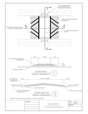


Please let us know what you think about this and if there are any aspects of the drawing that you would like to have further explanation.
Thursday, April 10, 2008
Real World Example
The video posted in an earlier post was from Yates Austin of North Carolina. I have been talking with him about how he has come to use Google Sketchup over time. Here is a summary along with a couple of images that he has sent me:
I started using Sketchup 5.0 in late 2005, not too long before Google acquired @Last Software, the creator of Sketchup. I am a CAD operator, with a background in Architectural design and visualization. I transitioned to working on Civil and Structural Engineering projects in late 2007 and introduced Google Sketchup to our office. The benefits of using Sketchup for presenting complicated design information to a non-technical audience was recognized early on, and I’ve begun hosting Lunch & Learn Sessions with the free version of Sketchup 6.0 for civil, structural and geo-technical engineers, geologists and geo-physicists within our office.
Attached are two images of a concrete labyrinth spillway dam. Much of the 3D Geometry for these images was generated in both Civil 3D 2008 (dirt embankments and grading) and Architecture 2008 (concrete walls and slabs).
Happy Sketching!


Subscribe to:
Posts (Atom)


 Posts
Posts

